





Designed for precision agriculture
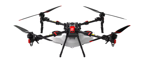
XAG M500 Remote Sensing Drone flies autonomously to capture high-definition images with high-performance data processing — helping you map, scout and grow smarter.
Remote Sensing Drone
Seeing The Big Picture In Every Detail WATCH INTRO VIDEO


Designed for precision agriculture
XAG M500 Remote Sensing Drone is designed for precision agriculture, with the capability to fly autonomously and capture high definition images with high-performance data processing. Partnering with XAG M500, you can better understand your farm to enable timely and effective actions. Map precisely The XAG M500 can help build a digital map of your farmlands, in which each plot and each crop has its own coordinate that allows precise operation of autonomous drones and robots. Scout effortlessly The XAG M500 can fly autonomously at high-frequency to capture overall farmland images. Without getting their feet on the ground, farmers can master every change of their fields with ease and take timely measures. Grow smart By taking advantage of third-party AI software, the XAG M500 can help you gain insight into plant growth and identify crop abnormity. Decisions are made with science to enable variable-rate spraying and fertilization.


The Smart Core to Agrifuture
SuperX 4 Pro, XAG's self-developed Intelligent Control System, are equipped with multi-tasking ability to endow XAG M500 the power of fully autonomous flight at cm-level accuracy. Real-time image stitching allows map creation immediately after landing.
Enhanced Flight Safety
AI fault prediction + emergency protection mechanism
6-core CPUs + NPU
30-hectare Real-time Image Stitching CAMERAS
Seeing the unseen
Four switchable cameras can capture multi-dimensional data from field overview to crops growth status. Reveal hidden but valuable information to help manage your farm with lower operation cost. XCam 20MP Pro Gimbal Camera¹ 20 MP 1" CMOS Sensor, high-resolution imaging DSLR-level ISP, ensures high image quality Ground Control Point-Free Used for Orthophoto & Oblique Photography XCam 26MP APS-C Gimbal Camera² 26 MP APS-C CMOS Sensor, better image quality Photos in Five Directions, supports 3D modeling 0.4s Shooting Interval, improve mapping efficiency Used for Orthophoto & Oblique Photography XCam 20H Hybrid Gimbal Camera³ Infrared & 20 MP 1" CMOS Sensor Temperature measurement at ±3℃ accuracy Used for HD Map & Thermal Map XCam 20M Multispectral Gimbal Camera⁴ 20 MP 1" CMOS Sensor & 4-Channel Multispectral Sensor, pixel-level image registration Automatic Sunlight Compensation leads to more accurate spectrum data (*currently this function is not supported) Real-time NDVI Video reveals…
Easy control with one screen
XAG SRC1 Smart Remote Controller, with its built-in touchscreen and XPilot APP, allows freely switch between autonomous flight and manual control. Multiple flight planning modes are available to meet your needs of various application scenarios. The 4G communication system support stable and long-range internet connection. XPilot APP⁵ Easy flight planning 5.5" 800 Lumens HD Touchscreen Clear visual under strong light 4G Stable signal & image transmission 4.5h Duration⁶ Suitable for longer task Field Mapping Oblique Photography Strip Mapping Precision Agriculture
Mapping your farm into precision agriculture
Weeds Control Practices The XAG M500 can be used for weed detection on crops, with the weed zone identified and located via the third-party AI software. Then a prescription map will be sent to the XAG agricultural drones for variable-rate spraying that can remove weeds with less pesticide use. Fertilization Management The XAG M500 can collect crop growth data and produce digital field maps to be analysed by the AI software. The AI prescription map will be generated and guide the XAG agricultural drone to spread fertilizers on where necessary. Improve yields with reduced fertilizers. Cotton Boll Opening Control The XAG M500 can create an HD cotton field map where the immature boll opening can be discovered and tagged. When receiving the labeled map, the XAG agricultural drones will conduct defoliation on target zones to facilitate large-scale mechanical harvesting. XAG Australia Smart Agricultural Solutions


Interested in this product?
Contact our team for pricing, demos and support.